
TOPOGRAPHIX to provide Ground Penetrating Radar (GPR) to The Lost Clipper project
December started with some great news as the Lost Clipper team is plowing forward in our efforts to return to Micronesia in 1Q 2018. We’ve teamed with Mr. Robert W. Perry of TOPOGRAPHIX® LLC out of Hudson, New Hampshire to provide Ground Penetrating Radar (GPR) surveying services to help pinpoint and find those 15 Americans lost in 1938.
Per the TOPOGRAPHIX website:
“GPR Mapping is non-intrusive, sub-surface imaging that looks underground to develop a picture profile of what lays below the surface. We use GPR to determine the location of unmarked graves, headstones and burial vaults. We can also locate lost or available grave space, markers that have been moved and verify casket positioning.
For cemeteries with missing or destroyed burial records, a GPR survey can produce a composite site map of an area that would indicate grave locations, positions and their depth.”
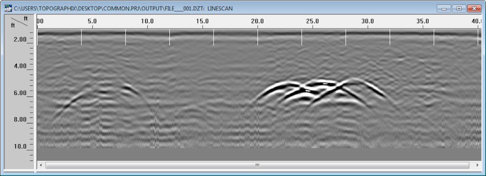
Here’s how GPR works…
Using TOPOGRAPHIX’s Ground Penetrating Radar, we’ll now be able to investigate and map sub-surface areas for the locations of mass burial sites, underground evidence, and buried human and metallic remains.
Guy received training in 2012 on a smaller Ground Penetrating Radar unit which was taken to the island later that year…
We’re very excited to welcome Bob Perry and TOPOGRAPHIX to The Lost Clipper effort!

Thank you for sharing this blog with me Mr. Perry! It is a very interesting project, I cant wait to see what you find as you piece together this history mystery🙏🏻
LikeLike